UNMANNED AERIAL SERVICES
Drone Data Guy is the unquestioned leader in the Midwest for thermal drone recovery, inspection, and mapping services. We elevate industries through aerial expertise.
Cutting-Edge Drone Services for Every Need
From thermal recovery to precision mapping, we provide the aerial data you need to make informed decisions.
Lost Pet & Large Game Recovery
Our high-resolution thermal drones can see through the canopy to locate your lost dog or downed deer, day or night.
Thermal Inspection
Identify energy loss, moisture intrusion, and electrical hotspots on roofs, solar panels, and infrastructure.
Mapping & Surveying
High-resolution orthomosaics and 3D models for construction, land management, and engineering projects.
Site Scouting
Get a bird's eye view of your property for development, hunting, or real estate. Identify features and terrain effortlessly.
Volumetrics
Accurate stockpile measurements for inventory management in mining, construction, and agriculture.
Construction Monitoring
Track progress, document site conditions, and improve communication with stakeholders through regular aerial updates.
Pioneering Aerial Solutions
Drone Data Guy is a premier provider of unmanned aerial services in the Midwest. We combine cutting-edge drone technology with expert piloting to deliver data that solves real-world problems.
Whether you need to find a lost pet in the dark, inspect a cell tower without climbing, or map a construction site with centimeter-level accuracy, we have the tools and expertise to get the job done safely and efficiently.
FAA Certificated
Fully licensed Part 107 pilots operating in compliance with all federal regulations.
Highest Quality Equipment
We fly the latest enterprise-grade drones with high-resolution thermal and RGB sensors.

Why Choose Professional Drone Services?
Quantifiable benefits that transform your operations while ensuring safety and compliance.
Increased Safety
Eliminate worker exposure to hazards like falls and electrocution. No ladders or scaffolding needed in dangerous areas.
Faster Operations
Complete inspections in 10-30 minutes instead of days. Automated flights with 30x quicker data gathering than traditional methods.
Cost Reductions
Lower personnel and equipment needs with reduced insurance liabilities. Higher precision at a fraction of traditional costs.
Better Communication
High-resolution thermal and RGB imagery with geo-tagged 3D models. Saved mission profiles provide consistent repeatability for accurate before/after and progress comparisons.
FAA Part 107 Certified
$1M+ liability coverage with LAANC approvals and waivers. Full regulatory compliance in restricted airspace operations.
Enhanced Marketing Impact
Unique angles and immersive fly-through and orbital footage optimized for MLS and social media drive higher audience retention and conversion rates.
Proven Results, Tangible ROI
Our methods deliver powerful outcomes across industries. Here are examples of the quality and impact our services provide.
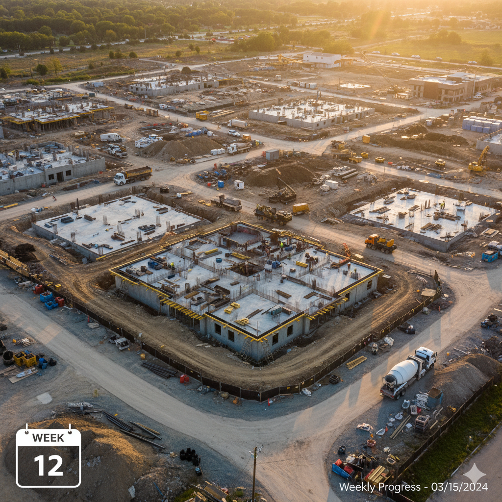 Construction
Construction Progress Monitoring
Weekly site updates provide stakeholders with clear progress visuals, improving project timeline accuracy.
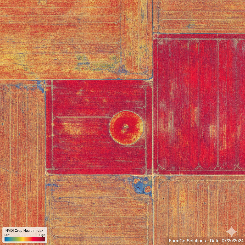 Agriculture
Field Maps, Crop Count and Density
Get precise field information for import into industry software. Track total plant counts and progress. Identify irrigation issues to enable targeted intervention.
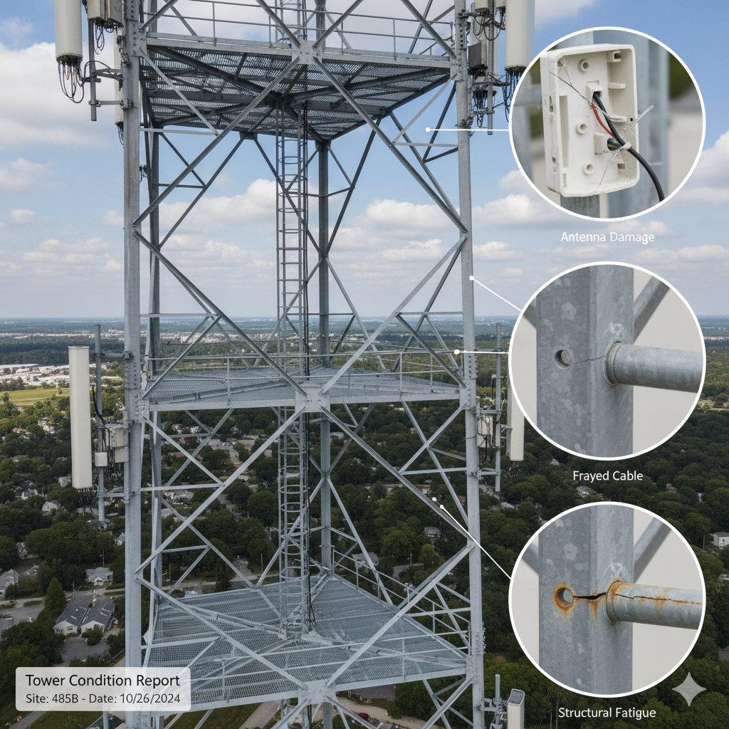 Infrastructure
Asset Integrity Inspection
Complete detailed aerial inspection of cell towers reduces inspection time by up to 75% compared to manual climbing inspections.
 Insurance
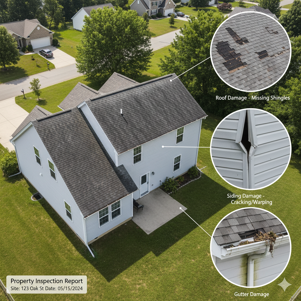
Post-Storm Damage Assessment
Comprehensive aerial documentation of property damage accelerates the insurance claim process. Targeted research of storm damaged neighborhoods.
 Thermal
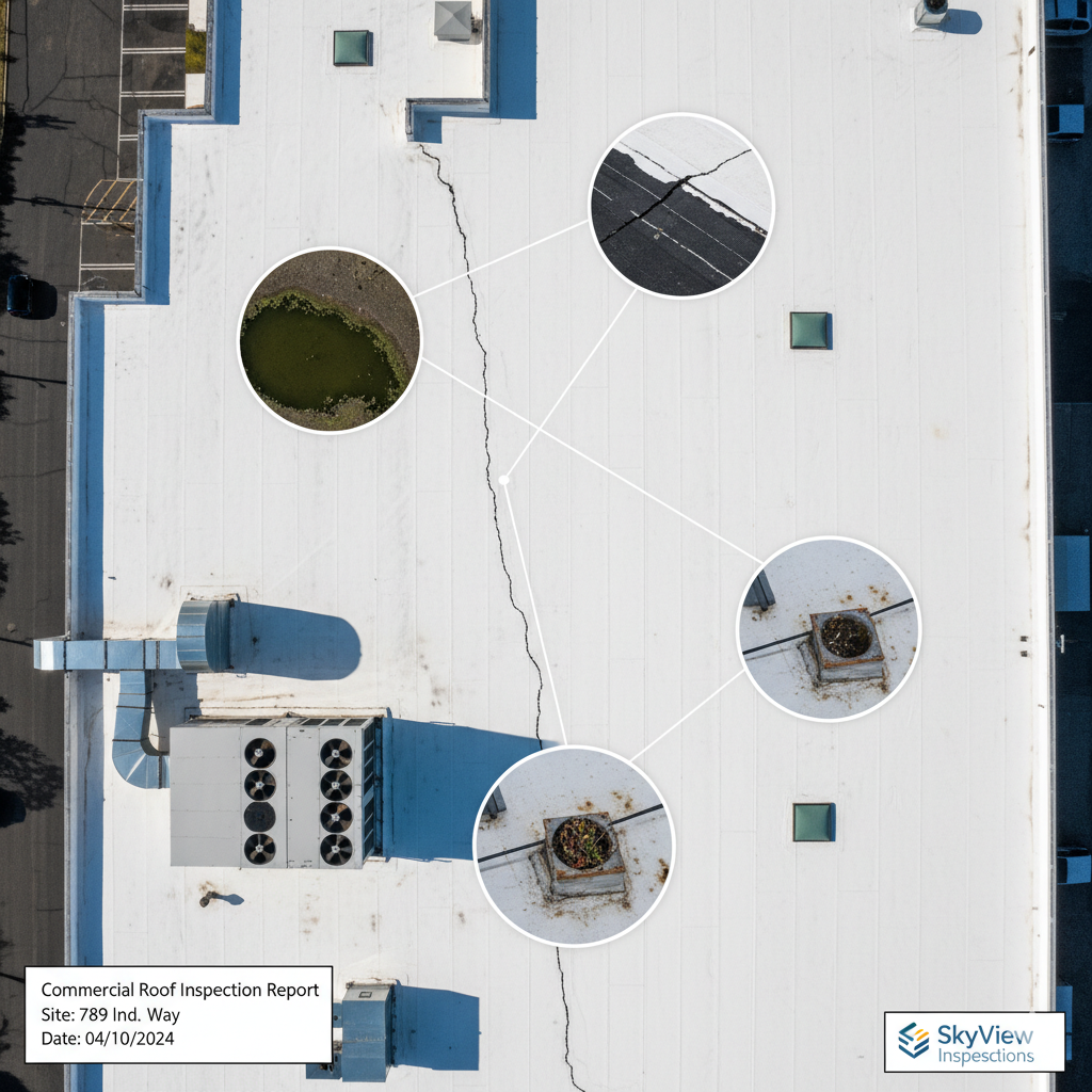
Thermal Roof Assessment
Infrared imaging can help detect moisture and insulation issues early, preventing costly repairs through early detection.
 Solar
Solar
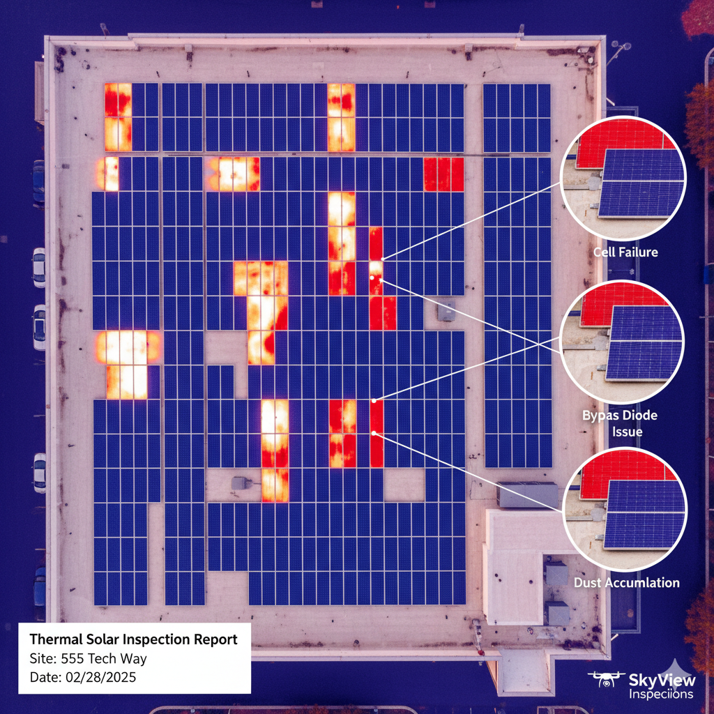
Solar Panel Efficiency Analysis
Thermal scans identify underperforming panels and inverter hotspots, optimizing energy output with 30-50% cost savings over ground inspections.
Service-Based Pricing
Transparent rates tailored to your specific needs. Get a clear price for the job you need done, without paying for bundled extras you don't. Web-based deliverables with sharable links make sharing results easy.
Real Estate & Media
Stunning visuals for real estate, marketing, and events.
From $250
Flat Rate Per Lot
- Photo & Video Package
- Bird's Eye Views Boost Property Sales
Inspections
Safe, high-res captures and 3D modeling of hard-to-reach assets.
From $350
Per Structure/Asset
- Safer, Faster Data Acquisition
- Up to 30% Cost Savings
Lost Pet & Livestock Search
Rapid deployment for help locating lost pets or farm animals.
From $125/hr
2-Hour Minimum
- 24/7 Availability
- Live Video Feed
Agriculture & Forestry
Optimize crops and manage timber resources.
From $15/acre
Volume Discounts Available
- Field Navigation & Density Maps
- Plant Count & Weed Cover Analysis
Construction, Surveying & Mining
Track progress, manage logistics, and ensure site safety. Create high-fidelity digital twins and accurate land modeling with full-color point clouds, orthomosaics, digital surface models, and 3D textured meshes. Manage excavations and stocks for efficiency and safety.
Custom Quote
Subscription or Project-Based Pricing
- Weekly, Bi-Weekly, Monthly Flight Options
- Progress Tracking & Volumetric Measurements
- Centimeter Accuracy with RTK Available
- 98-99% Accuracy vs. Ground Methods
- Excavation & Stock Reports with High-Accuracy 3D Models
Thermal & Roof Inspections
Infrared thermal imaging for moisture, leak, and defect detection.
From $275
Per Building/Structure
- Fast Inspections
- Flaw Detection & 360° Zoom
Solar Panel Inspections
Thermal scans for panel efficiency and defect analysis.
From $12/kW
Based on System Size
- Dead Cell & Hotspot Detection
- 30-50% Cost Reduction
Waste & Water Management
Model topography for water flow and calculate waste site metrics.
Custom Quote
Based on Project Scope
- Water Flow & Runoff Modeling
- Airspace & Compaction Reports
Our Proven 4-Step Process
A standardized workflow ensuring consistent, high-quality results for every project.
Planning
Define flight routes, mark boundaries, and select optimal sensors (RGB, thermal, etc.) for your specific requirements.
Execution
Launch autonomous flights with real-time data capture. Typical flights gather data within hours, with precision accuracy.
Processing
Advanced photogrammetry processing to create 3D models, annotations, point clouds, orthographic 2D outputs, thermal maps, and comprehensive analytical and accuracy reports.
Delivery
Receive geo-tagged files with actionable insights, enabling precise before/after comparisons and informed decision-making.
Addressing Your Concerns
We believe in full transparency. Here are answers to common questions about our drone services.
Ready to Take Flight?
Let's discuss your project. Fill out the form below for a free, no-obligation consultation and quote.